Showing posts with label portland streetcar. Show all posts

Sunday, July 18, 2010

Time for Plan C?

The Lake Oswego transit project has been a hot topic there this weekend.  The latest cost estimate for the project is nearly double previous estimates.  Some of that cost is the result of changing estimates for the value of the Jefferson Branch real estate, a cost which is already paid for (it's both a debit and a credit on the books), and will be matched at 1.5x--the "out of pocket" costs for the region are more in the range of $50-$75 million.  However, the size and scope of the cost increase is a bit disturbing, and isn't entirely accounted for by the ROW value.  (Not even close).  The politics are lousy, to be frank.

The problems

There are two bigger problems, however.  The projected "out-of-pocket" costs (excluding the ROW) to the region are expected to be a small fraction of the overall cost of the thing--$50-$75 million or so.  That actually looks good--if the region can get a 6x-9x multiplier on its cash investment, it might be a good deal.  The flies in the ointment are these:
  •  Until an appraisal is done, the actual value of the ROW will not be known.  Appraisal probably won't be done for a while; and may be an avenue for opponents of the project to tie it up in court.  (Those trying to sabotage the project may argue for a lesser value; those trying to cash in if their adjacent property is condemned may try to escalate the value).  A proper project budget depends on this, obviously.
  • The technical parameters of the project are... underwhelming.  The proposed route is no faster than the existing parallel bus line (it is expected to offer improvement when projected traffic increases tie the bus up in traffic); the capacity of the project is very low by mass transit standards (less than 1000 pphpd, assuming single-car Streetcars at no better than 10 minute headways); and the land-use potential seems limited.  Other than the SOWA area, and perhaps the Foothills area in Lake Oswego; most of the land along the line is either already developed, or geographically unsuitable for development.  (And those portions outside the Portland city limits are outside the scope of Portland Streetcar's organizational mission).  Given that--why would the FTA consider spending $240 million on this project, over other worthwhile projects in the country (and even possibly in the Portland area)?  Peter DeFazio might be in a position to steer an earmark Portland's way if the Democrats retain control of the House; beyond that, prospects strike me as dubious.  Given that the region will need to spend another $25 million or so to get to the point of submitting an application for the funds--money that will NOT be matched or reimbursed should the feds say no--is there a better way?
Plan B

The Streetcar alignment (including the trail option) is Plan A, of course.  There is a Plan B--the "enhanced bus" option.  In this option, no Streetcar is built; the ROW is used for a trail, and limited-stop bus service, augmenting or replacing the 35, runs along the OR43 corridor, with limited stops north of Lake Oswego.  Unfortunately, the "enhanced bus" option runs along 10th/11th through downtown, rather than the transit mall, a flaw which the proposed Streetcar alignment shares.  I suspect this routing was done to make the "enhanced bus" option a substitute for the Streetcar option--but if you're a cynic who thinks the bus option is only there because the law says it has to be, and isn't being seriously considered--this routing sure looks like a poison pill.

There is also "Plan Zero"--no-build.  Here, no capital improvements are made to either rails, trail, or bus infrastructure, and the 35 runs as before.  It is on TriMet's list of Lines To Promote To Frequent Service, but the agency is having trouble maintaining current levels of service.

Plan C?

Let's assume, for a moment, that we decide Lake Oswego Streetcar isn't a great idea--but that transit in the OR43 corridor is going to be a pressing concern in the next few decades.  Assume that population and traffic projections a few years hence are accurate, and OR43 will no longer be a convenient route for busses to use, due to congestion.  For riders from Oregon City, switching to the 33/MAX will be an option, but for riders from West Linn, that won't be.

Ignore the trail, for a bit.

And assume that the funds that the region were planning to use on the Streetcar could be invested on some other piece of infrastructure in the region.  What would be a good option?

Transit bridge across the Willamette, perhaps?  

In Metro's high capacity transit plan, one of the longer-range transit corridors connects Clackamas Town Center with Washington Square.  While the endpoints are strange--there is a substantial amount of workers living in places like Happy Valley, and working in Washington County.  Right now, commuters south of town who need to cross the Willamette must either head south to Oregon City, or north to downtown.   Imagine the potential of a transit bridge between Lake Oswego and Oak Grove.

  • Should either traffic congestion or operational efficiencies require it, the 35, 36, and 37 could use the New Bridge and connect with Milwaukie MAX at Park Ave. or Milwaukie TC.  (Some service should probably continue along OR43; but MAX could become the primary conduit).  A MAX line should be able to whisk commuters downtown faster than the proposed Streetcar line would.
  • Many of the east/west lines terminating or passing through either the LO and Milwaukie TCs (such as the 36, 78, 29, and 31) could be "linked up" as through east/west lines.
  • While this proposal doesn't assume that rail goes across the bridge at its opening, it does assume that this is an eventual possibility.   One possibility would be to build the bridge as an extension or branch of Milwaukie MAX, and put rails and catenary on the bridge at the beginning.  But it isn't necessary for the purposes discussed here.
  • The bridge would naturally include facilities for pedestrians and bicycles.  Not for automobiles, however.
There are several potential locations for such a bridge.  The most likely option would probably be adjacent to the existing railroad bridge, or possibly even replacing it.  (One evil thought:  build a new rail bridge upstream connecting the Willamette Shoreline tracks with the Samtrack rails; run P&W freights on THAT, and convert the existing line between Lake Oswego and Milwaukie to exclusive transit use.   I'm sure folks in Riverdale would love that...)   Another option would be somewhere in the Courtney/Terwilliger corridor; or possibly the Oak Grove corridor.  (Both of these latter crossings would be south of the planned terminus of Milwaukie MAX; though both are likely to attract more NIMBY opposition).

A recent estimate of how much such a bridge would cost was in the order of $200 million (courtesy of frequent commenter RA Fontes, who has been advocating such a bridge for a while now).   Given a 1.5x match, that would mean $80 million out of local coffers to build it.   But given the escalating pricetag of the Lake Oswego streetcar, this seems like a much better deal for taxpayers, who would be getting a more regionally-important facility than the proposed Lake Oswego streetcar line.


What about the trail?


So far, I haven't discussed the trail portion of the project.  If either no-build is done, or the "enhanced bus" option is selected, it is generally assumed that the Jefferson Branch ROW will be used for a trail instead.  For portions of the line, there are issues with the existing easement, which might require use of eminent domain to fashion a new easement.  On the other hand, a new bridge across the Willamette would provide trail users a new option:  connecting to the Trolley Trail and the Springwater trails on the east side of the river. 
What about Johns Landing?

One remaining question:  What about Johns Landing and the rest of the Macadam area?  The current Streetcar planning has identified a minimum operationally-usable segment (MOUS) from SoWA down to Nevada Street; with the possibility of extension to and across the replacement Sellwood Bridge when built.   I'm in agreement with blogger Erik Halstead--a frequent TriMet critic--who opines that building the MOUS makes sense.  Having Streetcar run extended down towards Johns Landing would provide opportunities to speed up the 35, 36, and 43 through the area.  However, were this to be done, I expect that this would be a typical Streetcar project, not a rapid transit project, and should be designed and funded as such.  Things like more frequent stop spacing would be appropriate, as the line would no longer be charged with getting Clackamas County commuters to the office.

Thursday, July 15, 2010

Sticker shock

In the past weeks, I've a handful of posts about the Lake Oswego Streetcar project, either directly or indirectly.  The tone of the articles has been less than enthusiastic, generally--as I've been searching for the right balance between expanding high(er) capacity transit and serving existing needs.  One thing in favor of the LO project, though, has always been its relatively low cost, particularly including sunk costs.  Back in the 80s, the Jefferson Street Branch line was purchased from Southern Pacific for $2 million, and is now apparently worth around $80 million (though the recent downturn in the real estate market may lower that figure; an earlier article here quoted a figure of $50 million).  Given that the value of the right-of-way could be used for Federal matching purposes (up to a 1.5x match), the project seemed to be a good way to get a decent rapid transit line on the cheap. 

However, word now comes today from the Portland Tribune (hat tip to bojack via Al) that the price tag for the project is now in the range of $380 million to $458 million.

Ouch.

Time to break out the Dr Evil photo.

"Four... Hundred... and Fifty.... MEEELYUN dollars!"

Only I don't hear the delegates to the United Nations--or anyone else for that matter--laughing.

The good news, I guess, is that the "local match" is only $47-55 million, excluding the value of the Willamette Shoreline ROW. 

The bad news is that if the estimated value of the ROW goes down, potentially 1.5x that shortfall must be made up elsewhere.  Also, the match depends on re-authorization of a federal transit funding bill that expired last year; and while Congressman DeFazio has lots of clout in the House; this is the sort of thing that might find a hostile reception in the Senate, where one party seems determined not to spend any money on anything that might stimulate the economy. 

Of the $50 million or so in cash that local governments must find under the cushions, half of it needs to be spent up-front and would be lost were the project to get canceled (or not approved).  And only if the project is built do any Federal matching funds get provided.

Of bigger concern seems to be the ever-increasing budget for the thing.  In 2007,  according to the Daily Journal of Commerce, the projected cost of the line was $149 million for the transit portion (and another $83 million for the trail portion).  Now the cost is almost double. 

To quote Lando:  "This deal keeps getting worse all the time!"

The good news

The good news, of course, is that the increasing costs are being made public before construction begins.  This is a sign that the project is at least being run in good faith.  (Compare that to the Portland Aerial Tram, which didn't see its budget triple until construction had already begun; an audit revealed that OHSU managers had kept overruns to themselves until sufficient costs had been sunk, and canceling the project was no longer an option).  Some dollars have been spent on early planning; and more money is to be spent to complete the DEIS; but this is a small fraction of the total cost.  Sometimes, spending money to discover that something is a Bad Idea is necessary.  That said, even with the steadily increasing budget, the out-of-pocket price for a seven mile rail line still is not bad.  Were the existing ROW not available (or not available for a federal match), this project would probably be DOA; but at this point, it's still got legs.

Why?

An important question to ask is "why".  Not just why this project has seen its budget grow faster than dandelions, but transit projects in general.  The US economy, after all, is in a recession.  Lots of people are looking for work.  The spectre of deflation (an outcome which would make rich people very happy, and most of the rest of us suffer) is rearing its ugly head--and as noted above, the Senate (or a particular faction therein) seems to desire this outcome.   Yet the costs to build public works projects seem to be skyrocketing.   It's interesting to compare recent transit rail transit projects in the area:

  • Original MAX (1982-1986):  $214 million, 15 miles (approx $400 million in 2010 dollars, $27 million/mile)
  • Westside MAX (1993-1998):  $963 million, 18 miles (approx $1.4 billion in 2010 dollars, $78 million/mile, including a tunnel)
  • Airport MAX  (2001):  $125 million, 5.5 miles (approx $155 million today, $28 million/mile)
  • Interstate MAX (2000-2004): $350 million, 5.8 miles (approx $400 million in 2010 dollars, $69 million/mile)
  • Green Line/Transit Mall (2007-2009): $575 million, 8.3 miles ($590 million today, $71 million/mile).
  • Milwaukie MAX (estimated):  $1.4 billion, ~7 miles ($200 million/mile, including a bridge)
A definite trend can be observed... but again, the important question is "why"?  Heck if I know.  I can think of numerous possibilities (most of them no good), but as I have no particular evidence at hand to suggest what may in fact be the cause of the rapid cost escalation experienced in the past decade, I'll just leave it there.

Why?

Saturday, July 10, 2010

Rapid streetcar, Portland, and the rail divide

There's an article on the light-rail advocacy site lightrailnow.org, which introduces a concept known as Rapid Streetcar.  Rapid Streetcar, as they define it, is a rail transit system which is a hybrid between "traditional" mixed traffic streetcars, and light rail systems.  With a rapid streetcar design, streetcar-class rail vehicles (which weigh considerably less than light rail vehicles) are operated in exclusive rights-of-way in urban areas, often in lanes which were previously dedicated to automobile service, and often in multi-car trains.  The page goes into detail on the advantages (lower construction cost, ability to run in mixed traffic if necessary, the possibility of tram-train like operation) and limitations (speed and capacity) of such systems, and discusses Portland's rail systems in great detail.

Of course, there's one catch:  Portland doesn't HAVE any Rapid Streetcar.  The article primarily uses Portland's streetcar system as an example of how such a system might be designed (focusing on details such as construction costs and techniques, station design, etc), while glossing over the fact that Portland Streetcar is, at present, a mainly mixed-traffic circulator system, not something marketed as rapid transit (or rapid anything).  Portland does have rail lines with service parameters that satisfy the conditions for Rapid Streetcar--but those lines (such as the Yellow Line) are running light-rail rolling stock, not streetcars.  There has been some discussion of Rapid Streetcar in Portland, but currently none exists.

As the article notes, "Rapid Streetcar" is not really a novel idea; many European tram systems have been operating in this fashion for decades.  It is more novel in the American context--the legacy streetcar systems which operated in the early 20th century before being replaced with busses and the automobile, were almost always mixed-traffic types; and many of the "revival" streetcars, such as the Portland Streetcar, are this way as well.

The Portland rail divide

The Portland metropolitan area has three transit rail systems in operation; this post compares the three systems (along with two "full metro" systems in other West Coast cities).  The remainder of the present article will ignore everything but MAX and Portland Streetcar.
In many ways, the two systems are dramatically different.  MAX is a traditional light-rail system, operated by TriMet--a mobility-focused transit agency which also provides bus service to the bulk of the metro area.  MAX uses light-rail class vehicles (such as the Siemens S70), usually running in two-car trains.  It runs almost exclusively in its own right-of-way, and in many places it is built to "light metro" standards, with grade separation or guarded crossings.  Other than the downtown area, average stop spacing on MAX is generally 3000-3500 feet (1km); and average speed on the system is about 20MPH (32km/h).  MAX operates on the proof-of-payment system, with tickets vended at platforms.  The fare structure for MAX is the same as for TriMet's bus system (with the added benefit of the Free Rail Zone downtown); service is branded similarly to the busses (both use the same colorschemes); and MAX is not marketed in any way as a premium or upscale service.  (Many of the MAX lines pass through parts of town regarded as blighted, and the "MAX causes crime" meme is unfortunately popular ).   

Portland Streetcar, on the other hand, is a different beast.  While TriMet drivers drive the trains around, the Streetcar is owned and operated by Portland Streetcar Inc (PSI), a subsidiary of the City of  Portland.   Unlike TriMet, PSI is focused on urbanist and community-development outcomes; on "placemaking".   The Streetcar uses streetcar-class vehicles (the Skoda 10T) operating in single-car units, and provides local circulator service through downtown Portland.  It operates in mixed traffic, mostly on streets of secondary importance.  Average stop spacing is about 750' (230m), or about once every three blocks.  Average speed is less than 7MPH (11.1 km/h); slower than many busses.  The Streetcar also uses the same fare system as MAX and the busses (and passes and transfers are interchangeable between the systems)--however, the Streetcar is marketed differently, with a brightly-colored colorscheme and styling aimed at more upscale riders.  Onboard amenities are similar.  The Streetcar also operates on a proof-of-payment basis, albeit with ticket machines onboard rather than at platforms.

Divide is perhaps too strong a word--as the two systems coexist fairly well.  The two agencies are on friendly terms, despite differing missions, and the systems are presented to the public as parts of a unified transit system.  Presently, they cross each other in two places (at Portland State University, and where the Yamhill/Morrison and 10th/11th couplets intersect), with a third crossing near the Portland Convention Center coming in 2011 when the Streetcar Loop project opens.  However, at the present time, the two systems are completely separate--separate routes, seperate rolling stock, separate yards and maintenance facilities, separate organizations, and separate missions.

Change coming

The opening of the Streetcar Loop project in 2011 won't change any of this.  However, when the Milwaukie MAX line opens in 2015, a shock to the system will come.   The new Caruthers bridge, which will ferry MAX across the river south of downtown, will also carry Streetcars as the Streetcar Loop project is completed to become a real (bidirectional) loop winding through both sides of the Willamette River.  For the first time, MAX trains and Streetcars will share the same tracks while in revenue service.  They won't share any stops--Streetcars will pass through the MAX stop on the west side of the bridge without stopping (and the lines diverge immediately after that), but they will share rails and catenary.

The next planned Streetcar project after the Loop is the Lake Oswego transit project, which everyone expects will select Streetcar as the LPA (locally preferred alternative).   This project, planned as a southward extension of the current Streetcar service down the Jefferson Branch line, is being billed by some  (including local planners) as Rapid Streetcar.  However, the predicted speed of the line--approximately 19MPH (30km/h), is on the low edge for a rapid transit line.  South of South Waterfront, the line is projected to be fairly fast; however the present Streetcar route takes ten minutes between OHSU and PSU.  (Planned enhancements to the line should shave a few minutes off that; however the numerous stops along this stretch of the route limit the impact of track improvements).   Further, the proposed project may suffer from capacity issues--as much of the route is single-tracked, effective headways are limited to 12 minute (5 trains per hour), or 700 pphpd.  Finally, one other significant issue is that whereas the #35 bus (which the line intends to replace) travels the transit mall, the Streetcar extension would instead stay on the existing alignment along the 10th/11th couplet--a five block difference.  Many of the commuters from West Linn who use the #35 either work downtown or plan to transfer to another line on the Mall; and are not well-served by a line which instead takes them to the Pearl District).

Streetcars on the Mall?

Given all that--what if the Lake Oswego Streetcar, instead of being an extension to the existing line, were instead routed on the Transit Mall?  Doing so would provide the following advantages (albeit with the indicated conditions).

  • Better replace the #35 service than a 10th/11th alignment.  Operation on the Mall would deliver riders to the core of downtown Portland's commercial district, and to all the transfer opportunities found there.
  • Would make running trains--i.e. more than one car--a possibility.  As the current Streetcar alignment north of PSU runs through existing, mature urban fabric, and in mixed traffic, the service is limited to single-car "trains" in order to minimize impacts.  The transit mall, OTOH, already serves 2-car MAX trains (equivalent in length to three Streetcars) with no difficulty.  Much of the line south of PSU could more easily be expanded to accommodate larger vehicles; permitting the LO line to have capacities closer to what MAX can deliver.
  • To further improve performance, the proposed Harbor Drive transitway (connecting the new Caruthers bridge to Lincoln Street) could be modified to accomodate Lake Oswego bound streetcars, thereby skipping many of the intermediate stops
In short, running the LO Streetcar on the Transit Mall would separate the local service (the existing Streetcar line and the loop) from the rapid transit service (the Lake Oswego line).

Now how much would you pay?

[Map courtesy of City of Portland/thetransportpolitic.com ]

 But wait...there's more!

Last year, the  City of Portland and Portland Streetcar published a draft Streetcar System Plan, which was passed by the city council last September.  The plan is a document outlining where Streetcar service might go in the city of Portland in the future.  The document isn't intended to articulate future corridors for high capacity transit (see here for that); and limits its coverage to the city of Portland, not to the suburbs.  Most of the routes proposed are local circulators such as the current Streetcar; however the document does address Rapid Streetcar, further dividing it up into "enhanced local service" and "priority service", proclaiming the LO Streetcar extension to be the latter.  The Plan has this to say on the subject:


The rapid streetcar concept aims to combine the best features of streetcars and light rail transit (LRT) to achieve faster commute/travel times than streetcars and lower system costs than light rail. Streetcars are typically designed to go shorter distances in central cities, densely populated mixed-use centers and neighborhoods. Streetcars are also typically designed to operate in mixed traffic, preserving street traffic patterns.
 

LRT typically functions as regional high-capacity transit (HCT), generally traveling in a separated right-of-way with relatively fast-moving, larger-capacity vehicles designed to rapidly transport large numbers of people between suburban and urban centers.
 

The rapid streetcar concept would apply some of the LRT features to streetcars to improve travel times while keeping capital costs lower. It would combine features of a semi-exclusive transitway and transit priority features within the street right-of-way to achieve faster travel times and maintain lower system
capital costs. This could introduce two new levels of service to Portland’s system.
 

Several corridors under consideration for the Streetcar System Concept Plan are prime candidates to introduce Enhanced Local Service. These corridors are major arterials with 4 to 5 lanes and on-street parking such as NE Sandy Boulevard and SE Foster Road.  In Portland there are potential corridors for introducing priority service. Currently, the region is undertaking a study to extend the existing streetcar system along a former railroad right-of-way from the South Waterfront District, through Johns Landing and south to Lake Oswego. SE Foster Road and 122nd Avenue are also candidates where there may be sufficient right-of-way width to introduce streetcar priority lanes.
I encourage all readers to download and read the draft plan--even if (or especially if) you think local service streetcars are a boondoggle or a weapon of gentrification.  (The document probably won't change your mind, but it may make you angry).

In the plan, numerous potential Streetcar corridors are considered.  Several screening functions are applied to exclude those which are technically unfeasible, unlikely to draw sufficient ridership, or unlikely to promote transformative land use outcomes; with the remaining corridors grouped into tiers.  More filtering was performed, with the following routes surviving all the cuts:
  • MLK from Alberta to the Loop.
  • Thurman/18th/Burnside/Sandy.  NW 18th/19th couplet, south to Burnside, east to Sandy to the Hollywood District.
  • The loop
  • The current route, with extension to Lake Oswego.
  • Sellwood Bridge, between LO route and Tacoma Street MAX.
  • Gateway Loop
  • Goose Hollow to 3rd/4th to Morrison Bridge to Belmont to 39th to Hawthorne to 50th. 
  • Broadway/Weidler from loop to Hollywood.
The plan assumes that the Powell Boulevard and Barbur Boulevard corridors will be constructed as light rail, and assumes that no sharing of track between MAX and Streetcars will occur, other than on the Caruthers Bridge.  If, however, Streetcars could use lower-speed MAX routes to get around, it may be possible to eliminate some redundant routes downtown, or use the existing Ruby Junction yards to service the Gateway Loop.  For example, if connectivity to St. Johns were desired, but extending the MLK line were thought to be difficult, it might be possible to lay tracks from Interstate only, and then have trains run down the Yellow Line--or even augment (or replace!) the Yellow Line itself with streetcar service, as a way of dealing with the Steel Bridge bottleneck.

Technical difficulties

How technically (and politically) feasible is any of this?  Both systems use the same rail gauge (standard) and power system (overhead catenary supplying 750VDC), so two key requirements for mixing the systems are satisfied.   The following technical issues and restrictions do exist:
  • The signalling systems are presently different; unfortunately, I'm not aware of the technical details, or how much it would cost to retrofit them to be the same (I imagine the Streetcar, with far fewer miles of track than MAX, would be converted). 
  • The Skoda streetcars are about 8" narrower than MAX trains--introducing a 4" or so platform gap were a Streetcar to use a platform designed for MAX.  That gap, too wide to simply instruct users to mind, could be bridged with platform extenders.  (For obvious reasons, MAX trains cannot use Streetcar platforms--but there are many other reasons MAX can't run on streetcar routes).
  • MAX trains are too heavy to run on the current Streetcar route, which has a smaller railbed.  (The use of the lighter-grade construction is one thing that produces the cost savings attributed to Rapid Streetcar).  Nor could MAX take many of  the corners successfully.  
  • The Skoda 10T streetcars have a top speed of 40-45MPH (64-70km/h); making their use on the high-speed parts of the MAX network (anything west of Goose Hollow, the I-84, I-205, and Airport segments, and the Milwaukie Line south of Holgate) inappropriate.  Were a faster vehicle available, this would not be an issue.
  • According to Curt Ailes at Huston Street Racing, who interviewed Oregon Iron Works president Chandra Brown on the subject, the 10T streetcars cannot be coupled for in-service operation.  They have couplers, but Ms. Brown suggested that they aren't suitable for operational use.  (Perhaps they are only for towing the streetcars; but the model in question lacks the electronics for tandem operation of multiple units, and/or the horsepower for one to pull another).  Skoda makes other streetcars (such as the 14T and its successors) which can be formed in trains; but current practice in the North American streetcar market seems to be to use streetcars are larger busses, and to stick with light rail or metro for high-volume applications. 
In addition, there may be political objections as well.  As noted above, the two agencies have different missions:  TriMet has an operations focus (claims by its critics to the contrary nonwithstanding), and PSI is focused more on land use.   PSI board member (and Portland planning commissioner) Chris Smith indicated, in a conversation on portlandtransport.com, that the former agency isn't interested in the land use goals of the latter, noting that:

I think it would be fair to characterize streetcar supporters (including the City of Portland) as believing that as soon as the streetcar system is handed over to TriMet it will stop expanding. So unless TriMet changes its culture and mission I don't see the organizations being merged for a long time. 

While increased joint operation of the Streetcar and MAX certainly doesn't require a merger between the two organizations, Smith has a valid point:  Many in Portland's transit community take a dim view of Portland Streetcar, in particular it's land-use focus--and may extrapolate negative views towards mixed-traffic rail and transit-oriented development into opposition to streetcars (the technology), even in applications where they make sense from a transit-focused perspective.  And, there are probably many on the TriMet operations side who would look unfavorably to an additional vehicle type to deal with.

Final thoughts

Does running Streetcar technology and light-rail technology on the same tracks, beyond the planned Caruthers bridge concurrence, ultimately make sense?  It's hard to say--for specific lines, such as Lake Oswego, a good argument can be made.  Elsewhere in the system, arguments get sketchier.  Long range, it may be the case that a downtown subway is built to handle light rail, and that the surface routes become exclusively served by streetcar.  It may be the case that rapid streetcar is selected for future transit corridors such as Powell, which already runs parallel to light rail.

It's also possible that the Lake Oswego project won't survive the DEIS process in its current form; and Streetcar technology is for the foreseeable future only used for local circulators--making the whole subject moot.

But in planning for the future, it's good to keep an open mind, especially in an era where budgets are tight.  And just because a vehicle looks like a streetcar, doesn't mean it has to act like one.

Thursday, June 24, 2010

Lake Oswego transit DEIS slips to September

Earlier indications from Metro would be that the DEIS for the Lake Oswego transit project would be coming out soon ("summer"), appear to be off the mark.  Today, Metro issued a statement setting forth a new timeline for completion of the DEIS work, and selection of the locally preferred alternative.  Metro also published a fact sheet giving more details. 

According to the new schedule, the DEIS will be published in September, at which point there will be a 45-day public comment period, with the LPA selected in the November-December timeframe. 

According to some commenters here who have been following the project closely, some of the published data in the current planning documents has run aground on the sharp rocks of reality--one hopes that the DEIS will reflect these findings.  (And one hopes that the public comment period isn't entirely for show...)

Monday, June 7, 2010

Lake Oswego: A streetcar we should desire?

This is part two in a series about the proposed Lake Oswego/Portland project.  Part one covered the Jefferson Street branch line, the rail line along the Willamette which forms much of the right-of-way for a proposed streetcar line.
 
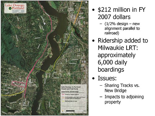
Today, we turn our attention to the another in-the works rail transit project being planned for Portland:  Lake Oswego to Portland Transit Project.  While this project is still fairly early in the planning stages, it has already proven itself to be controversial. Technically, of course, this isn't yet a streetcar project.  The Locally Preferred Alternative (or LPA--what the project sponsors ultimately tell the feds we want to build) has not been selected yet--as of now, three primary options are still on the table:
(Image courtesy of Metro via portlandtransport.com)
  • No-build, as required by law
  • "Enhanced bus service"
  • A streetcar/trail between Portland and Lake Oswego.
Completion of the draft environmental impact statement (DEIS), and determination of the LPA, is due sometime this summer.  If all proceeds according to schedule, the final EIS work would start in 2011, construction would start in 2014, and the line (assuming rail is chosen) would open in 2016.

I try to be objective as I can when it comes to transit mode debates, in particular bus vs rail.  Both technologies have their places, and their uses certainly overlap.  I'm a big supporter of MAX (despite having quibbles with certain parts of it).  While I've been a harsh critic of WES, the main problem with it is that the corridor in question is inappropriate for commuter rail--commuter rail, done properly, is an excellent transit option.  (Portland-to-Salem commuter rail, with a more frequent schedule and more frequent stops than Amtrak, probably would do well).  And while I'm kind of meh on the current Portland Streetcar (mixed-traffic streetcars don't offer any mobility improvements over busses, even if they are more comfortable and more palatable to certain demographics), I don't really have a problem with the current route.

But I'm a bit ambivalent about this one.

The options in detail

Before proceeding any further, it's worth considering the options in more detail:  Quoting from Metro, the options are:

No-build option

The study examines existing transit services and facilities and only those transit and highway improvements that are deemed achievable within financially constrained resources by the year 2035. This alternative is also used as a basis for comparison for the enhanced bus service and streetcar alternatives.

Enhanced bus service

The study includes an evaluation of potential bus improvements and transportation systems management techniques to benefit bus service between Portland and Lake Oswego. The enhanced bus service alternative would include frequent bus service between Oregon City and downtown Portland along Highway 43 with connections to the Lake Oswego transit center located on Southwest Fourth Avenue between A and B streets. The enhanced bus service would have fewer stops than a normal local bus service – similar in number to the streetcar alternative, more frequent service than the current TriMet Line 35, and a 300-space park and ride facility near the Lake Oswego Albertsons.
During the alternatives analysis for the corridor, more intensive capital improvements for a version of bus rapid transit, such as queue jump lanes at intersections, were evaluated for the corridor. These improvements are not a reasonable option due to community access impacts and the potential need to acquire private property.

Streetcar

The study evaluates streetcar operation between Portland and Lake Oswego, where the line would terminate near Albertsons. Park and ride facilities would be located at the terminus (300 spaces) and in Foothills (100 spaces). The streetcar option would study potential operation in the Willamette Shore Line right of way and design options where it may leave the right of way in in some areas.
During the alternatives analysis, streetcar running entirely on Highway 43 was dropped from study due to safety concerns. A minimum operable segment to the Sellwood Bridge is also being considered.
At the same time through a parallel process, steps will be identified to advance a trail in the corridor.

Ignoring the no-build option, which is required to be present in the analysis--the two options under consideration are a) enhanced bus service, with minimal capital improvements (a park and ride), and b) a new streetcar line--a highly capital-intensive project.  Early during the planning phase, a bus rapid transit line was considered (enhanced with queue jump lanes along the route), however this was scaled back to the limited-stop frequent service proposal now on the table.

The fact that the two options are so wildly different in cost and scope (a low-capital change to bus service, vs a new streetcar line), might serve as a red flag--as an indicator that one or more of the options under consideration is a straw-man.  It's not unheard of for planning officials to include no-way-in-hell options in a DEIS, that are are there only to be rejected so what they really want to build is all that's left.  In this case, though, there is a good reason for the widely divergent nature of the two options being considered.


You match my back...

There is, to be blunt, not much in the way of local money for this project.  The federal New Starts program will generally provide a 1.5x match on local funds for qualifying projects, but the local authorities have to come up with 40% of the cost.  However, there is a bit of a loophole which authorities plan to take advantage of (and have gotten approval to do so):  The local contribution doesn't have to be in cash.  As it so happens, there's a publicly-owned rail right-of-way, which has been valued at $50 million or so--the Jefferson Street line.  By building on the existing right-of-way, contributing IT to the project, the Feds will apparently kick in $75 million for the necessary improvements (rebuilding the track to modern specifications, electrification, stations and facilities)--and voila, a new rail line, with a minimum of cash out of local coffers.  Bus improvements, on the other hand, would be on OR43 and not on the rail ROW--hence the value of the right-of-way could not be counted as part of the local contribution.


(Image courtesy of Wikipedia)


(As an aside--conversion of the Jefferson Street line to a busway--or to a general purpose toll lane, as suggested by John Charles of the Cascade Policy Institute, would both be technically infeasible and illegal.  The easement on which the right-of-way sits only permits rail; otherwise it would revert to the property owners.)

This funding issue may also affect some of the design choices that are made.  One design option, assuming a streetcar line is built, is running one direction of track (or possibly both) along SW Macadam, instead of on the existing ROW; many local merchants would prefer having the tracks run past their front doors.  If a section of the ROW isn't used for the project, though, it's value doesn't count.  

This strategy isn't without its risks, of course.  There are many wealthy neighbors of the proposed line who aren't keen about streetcars passing by their houses every five minutes or so--and would love to kill the project.  I'm sure a few lawsuits will be filed challenging the project, on this and on other grounds.  (Many of these lawsuits may well be specious, but if TriMet has trouble keeping its busses running, can they afford to go to court?)  In addition, I'm sure there will be challenges to the valuation of the ROW, issued with the intent of decreasing the federal match and scuttling the project.  But that bridge will be crossed later.

So what's the problem?
Assuming that the rail option is taken and the project is completed, what will we have?  A seven mile streetcar line running down from Portland to Lake Oswego, which has the following properties:
  • Runs in an exclusive right-of way (or nearly exclusive; some design alternatives include a few mixed-traffic segments).  This is new for Portland Streetcar, whose current route (between South Waterfront and NW 23rd) and in-construction extension (the eastside loop) run mostly in mixed traffic.  An exclusive ROW is pretty much necessary for something to be considered "rapid transit", or even close--so this is a Good Thing. 
  • Is single-tracked for much of its length.  Single-tracking does limit capacity, especially if trains have to stop in the single-track section.  Planning documents indicate that the line will support 10-minute headways (whether operational dollars or demand will justify this level of service is another question), but having single-tracked sections does create a bottleneck--and is a Bad Thing.  Given that this line ends in Lake Oswego, and isn't planned to go any further, it's probably an Acceptable Thing; you wouldn't want extensive single-tracking on a main trunk line, on the other hand.
(Image courtesy of Metro)

So what's the problem--and why (other than the prospect of pissed-off wealthy landowners in Riverdale and Lake O) is this project so controversial?

It's an old story, one that gets told everytime a new rail line opens where bus service exists before:  Someone's one-seat ride gets whacked.  And in this case, with the Lake Oswego streetcar being noticeably slower than, say, Milwaukie MAX (which will also result in significant buswhacking across the river), and only serving half the length of the route served by the 35 Macadam/Greeley, the number of disaffected bus riders will be significant.

(Between Milwaukie MAX and Lake Oswego streetcar, Portland's planning and transit agencies are managing to build two lines halfway to Oregon City.  Just sayin'.)

The project Evaluation Summary, in chapter 5, addresses this issue with the following predictions trip length along the line for peak-hour traffic.
  • In-vehicle times between PSU and Lake Oswego:  Private auto, 28 minutes; #35 bus, 42 minutes; BRT, 33 minutes; Streetcar, 24 minues.
  • Total trip time between PSU and Lake Oswego:  Car 33 minutes; #35 bus, 48 minutes; BRT, 39 minutes; Streetcar, 30 minutes.
  • Total trip time between PSU and West Linn:  Car, 47 minutes, #35 bus, 68 minutes, BRT, 66 minutes, Streetcar, 57 minutes.  (Note that the streetcar requires a transfer to bus to continue to West Linn).  
"Total trip time", in all cases, includes wait times, walk times to reach parking or stops, etc.

These predictions, it should be noted, are not estimates for today--they are estimates for 2025.  The actual timetable for the #35 today indicates 29 minutes worst case for #35 between Lake Oswego and 6th/Washington, several steps beyond PSU.  From West Linn (Willamette Drive) to downtown, is presently 48 minutes.  Extensive additional congestion along OR43 is evidently being predicted--for which I refer you to the piece on population forecasting.  If these predictions do come true, then the LO Streetcar will be a quicker alternative for West Linn commuters needing to reach downtown.  If not, however, it will be a slower trip--presently, the #35 is pretty fast to reach downtown from Lake Oswego.

One other issue with truncating the #35 and requiring a transfer to the Streetcar is that the #35 runs down the transit mall--within a few blocks of Portland's downtown office buildings, and with many transfer opportunities to other lines serving other parts of the city.  The Streetcar, on the other hand, runs several blocks to the west.  If you ride the 35 to reach a job at Big Pink, you will have an additional hassle beyond transferring between modes in Lake Oswego.

One other issue

One other issue which merits mention:  By the time construction is scheduled to start, in 2014, the Milwaukie MAX line should be completed.  Which means that there would be light rail only about a mile from the proposed terminus of the Lake Oswego line.  Of course, the Milwaukie Line lies across the river, and extending it into Lake Oswego is presently not anyone's radar screen.  However, there is a long-term proposal to build a "southern corridor" light rail line between Clackamas and Washington Square, passing right through Lake Oswego, and intersecting Milwaukie MAX.  This might be a better alternative than the LO streetcar line in the long run; however, it isn't likely to happen (if at all) for more than a decade.

Final thoughts

So--is this a good idea?  Or is this a case of money (or in this case, land) burning a hole in someone's pocket?  It is claimed that there will be operational efficiencies realized by the project when it is complete.  A fully-loaded streetcar is cheaper to operate than the equivalent number of busses, and given that TriMet's bus fleet is entirely powered by combustion engines, may be more environmentally sound.  (That calculation depends on how the electricity is generated, and what fuel gets burned in the engine--we won't go into detail here).  It is claimed (section 5.3) that conversion to Streetcar will reduce TriMet's operating costs per year by over $1 million, compared to the no-build option (and that enhanced bus service will increase anual operating costs by almost $5 million). 
TriMet also predicts that the Streetcar will attract additional riders that bus service will not attract--entirely possible, given the demographic.  On the other hand, many public comments from Lake Oswego residents indicate an unwillingness to ride any form of transit.
If the congestion predicted for OR43 in the future does start to materialize, and Macadam becomes a parking lot, then the Streetcar may indeed offer time savings compared to bus service.  If not, then this project may represent a service reduction for many commuters (generally transit-dependent ones, as West Linn is not likely full of choice transit users given the low levels of service there)--which tends to not go over well. The shift of service from the Transit Mall to the existing Streetcar line along 10th/11th is likely to be an issue as well.
The bottom line is that the success or failure of this project will depend a lot on future population growth patterns in the region.  One significant urban reserve area is the Stafford Basin, which contains lots of buildable land in close proximity to downtown; were this to be developed it would put tremendous pressure on OR43.  But that's a development way out into the future.  For the present time, it will be at least four more years until construction gets started--hopefully, we'll have a better handle on Portland's long term growth prospects, but economic and population.  It may end up that the Lake Oswego streetcar project is not worth doing, and if that turns out to be the case, I hope that planners realize this before committing to the project. 
But that train has not yet left the station.

Thursday, May 13, 2010

The Jefferson Street Line

Later, I will (most likely) write an article on one of the Portland region's more controversial future rail projects, the Portland/Lake Oswego Transit Project.  Technically, it is incorrect to call this a "rail" project.  One of the options under consideration involves enhanced bus service rather than rail of any sort; in addition, a multipurpose trail is also part of the project definition (and a complicating factor given the terrain).  No final determination has been made, though a decision is expected later this year, when the DEIS is due for completion and selection of the "Locally Preferred Alternative" is made.

This post, however, will instead examine the existing rail route which is at the heart of the matter; the so-called "Jefferson Street" line which runs along the Willamette between SW Portland and Lake Oswego:

Early history:

The line opened in 1887 as the Portland and Willamette Valley Railroad, for the purpose of providing passenger service between Portland and Oswego (as Lake Oswego was then known).  Originally a narrow-gauge steam-powered line, the line was later purchased by Southern Pacific, converted to standard gauge, and electrified in 1914, forming part of the SP's Red Electric interurban service.

The original routing of the Red Electric lines (there were two of them) ran from Union Station down 4th Avenue; at Jefferson Street the lines split.  The westside line ran down present-day Barbur Boulevard, turned west at Hillsdale (running along what is now Beaverton-Hillsdale Highway), and then through Beaverton, Aloha, Hillsboro, Forest Grove, Yamhill, McMinnville, and south towards Corvallis.  Other than a short stretch between along OR47 between McMinnville and Gaston, where the ROW was abandoned and the tracks pulled up, most of the line past Beaverton still exists and is in service.

The eastside line turned east at Jefferson (hence the name "Jefferson Branch"), headed down towards (Lake) Oswego along the Willamette River, then turned west towards Durham, Tualatin, Sherwood, Newberg, and Dundee--the two lines rejoined at St. Joseph's Wye, near McMinnville.  Other than the downtown segments, all of the eastside branch is still in service.  The Portland-Oswego stretch was (and still is) single-tracked with one siding of note.  In 1921, a dangerous trestle around Elk Rock was replaced with the quarter-mile Elk Rock Tunnel, which is still in use.

Abandonment of passenger service:

In the 1920s, the expansion of the road network, and the resultant competition from bus service and private automobiles, reduced demand for passenger rail service--as a result, SP discontinued the Red Electric service in 1929, and eventually de-electrified all the routes in question.  The downtown streetcar lines along 4th would not long after be dismantled.  In order to keep freight trains out of downtown streets, the SP had in 1910 built the Lake Oswego Railroad Bridge, connecting the Jefferson line at Oswego with the SP mainline at Willsburg Junction north of Milwaukie.  With the passenger trains gone and the northern connection to the rest of the rail network severed (leaving the northern terminus of the line near what is now Riverplace) the Jefferson line soon became a little-used spur.  Several industrial customers along the waterfront in SW Portland still needed rail service, so the line remained in operation for another 50 years, but in in 1983, SP discontinued freight service and filed for abandonment.

One year later, the Interstate Commerce Commission agreed to permit the line's abandonment, but a group of local governments, recognizing the possibility of the line for future transit service (the eastside MAX line was about to begin construction at the time), petitioned to buy the line instead; the sale was completed in 1988.  One year earlier, a historic trolley service begin operation.

The purchase of the line, and its use for trolley service, was not without acrimony.  After the freight trains stopped running in 1983, one nearby homeowner, whose driveway was bisected by the line, paved over the tracks--a court injunction was required to get the pavement removed.

Historic trolley service

After the acquisition of the line was completed, historic trolley service resumed in 1990, has has continued, more or less, since then.  Several further changes have been made to the line, with an extension into downtown Lake Oswego (alongside the existing freight rails) added in the early 1990s, and the northern terminus moving north into Riverplace, and then back south to the present Bancroft Street terminus (the ROW north of Bancroft is now used by the Portland Streetcar).  Today, the service is known as the Willamette Shore Trolley, and is operated by the Oregon Electric Railway Historical Society

The present use of the line for historic trolley service, and future uses for transit, are not without controversy.  Many neighbors along the line (despite much of the housing being newer than the rails) would like to see the line abandoned, and object to the trolley service--viewing it as (among other things) an invasion of privacy.  At one point, the WST website  touted close-up views of luxurious Portland and Lake Oswego homes as an attraction of the line; such language has since been removed.


Resources: