

Today, we turn our attention to the another in-the works rail transit project being planned for Portland: Lake Oswego to Portland Transit Project. While this project is still fairly early in the planning stages, it has already proven itself to be controversial. Technically, of course, this isn't yet a streetcar project. The Locally Preferred Alternative (or LPA--what the project sponsors ultimately tell the feds we want to build) has not been selected yet--as of now, three primary options are still on the table:
(Image courtesy of Metro via portlandtransport.com)
- No-build, as required by law
- "Enhanced bus service"
- A streetcar/trail between Portland and Lake Oswego.
I try to be objective as I can when it comes to transit mode debates, in particular bus vs rail. Both technologies have their places, and their uses certainly overlap. I'm a big supporter of MAX (despite having quibbles with certain parts of it). While I've been a harsh critic of WES, the main problem with it is that the corridor in question is inappropriate for commuter rail--commuter rail, done properly, is an excellent transit option. (Portland-to-Salem commuter rail, with a more frequent schedule and more frequent stops than Amtrak, probably would do well). And while I'm kind of meh on the current Portland Streetcar (mixed-traffic streetcars don't offer any mobility improvements over busses, even if they are more comfortable and more palatable to certain demographics), I don't really have a problem with the current route.
But I'm a bit ambivalent about this one.
The options in detail
Before proceeding any further, it's worth considering the options in more detail: Quoting from Metro, the options are:
No-build option
The study examines existing transit services and facilities and only those transit and highway improvements that are deemed achievable within financially constrained resources by the year 2035. This alternative is also used as a basis for comparison for the enhanced bus service and streetcar alternatives.
Enhanced bus service
The study includes an evaluation of potential bus improvements and transportation systems management techniques to benefit bus service between Portland and Lake Oswego. The enhanced bus service alternative would include frequent bus service between Oregon City and downtown Portland along Highway 43 with connections to the Lake Oswego transit center located on Southwest Fourth Avenue between A and B streets. The enhanced bus service would have fewer stops than a normal local bus service – similar in number to the streetcar alternative, more frequent service than the current TriMet Line 35, and a 300-space park and ride facility near the Lake Oswego Albertsons.
During the alternatives analysis for the corridor, more intensive capital improvements for a version of bus rapid transit, such as queue jump lanes at intersections, were evaluated for the corridor. These improvements are not a reasonable option due to community access impacts and the potential need to acquire private property.
Streetcar
The study evaluates streetcar operation between Portland and Lake Oswego, where the line would terminate near Albertsons. Park and ride facilities would be located at the terminus (300 spaces) and in Foothills (100 spaces). The streetcar option would study potential operation in the Willamette Shore Line right of way and design options where it may leave the right of way in in some areas.
During the alternatives analysis, streetcar running entirely on Highway 43 was dropped from study due to safety concerns. A minimum operable segment to the Sellwood Bridge is also being considered.
At the same time through a parallel process, steps will be identified to advance a trail in the corridor.
Ignoring the no-build option, which is required to be present in the analysis--the two options under consideration are a) enhanced bus service, with minimal capital improvements (a park and ride), and b) a new streetcar line--a highly capital-intensive project. Early during the planning phase, a bus rapid transit line was considered (enhanced with queue jump lanes along the route), however this was scaled back to the limited-stop frequent service proposal now on the table.
The fact that the two options are so wildly different in cost and scope (a low-capital change to bus service, vs a new streetcar line), might serve as a red flag--as an indicator that one or more of the options under consideration is a straw-man. It's not unheard of for planning officials to include no-way-in-hell options in a DEIS, that are are there only to be rejected so what they really want to build is all that's left. In this case, though, there is a good reason for the widely divergent nature of the two options being considered.
You match my back...

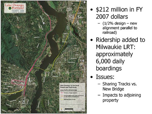
There is, to be blunt, not much in the way of local money for this project. The federal New Starts program will generally provide a 1.5x match on local funds for qualifying projects, but the local authorities have to come up with 40% of the cost. However, there is a bit of a loophole which authorities plan to take advantage of (and have gotten approval to do so): The local contribution doesn't have to be in cash. As it so happens, there's a publicly-owned rail right-of-way, which has been valued at $50 million or so--the Jefferson Street line. By building on the existing right-of-way, contributing IT to the project, the Feds will apparently kick in $75 million for the necessary improvements (rebuilding the track to modern specifications, electrification, stations and facilities)--and voila, a new rail line, with a minimum of cash out of local coffers. Bus improvements, on the other hand, would be on OR43 and not on the rail ROW--hence the value of the right-of-way could not be counted as part of the local contribution.
(Image courtesy of Wikipedia)
(As an aside--conversion of the Jefferson Street line to a busway--or to a general purpose toll lane, as suggested by John Charles of the Cascade Policy Institute, would both be technically infeasible and illegal. The easement on which the right-of-way sits only permits rail; otherwise it would revert to the property owners.)
This funding issue may also affect some of the design choices that are made. One design option, assuming a streetcar line is built, is running one direction of track (or possibly both) along SW Macadam, instead of on the existing ROW; many local merchants would prefer having the tracks run past their front doors. If a section of the ROW isn't used for the project, though, it's value doesn't count.
This strategy isn't without its risks, of course. There are many wealthy neighbors of the proposed line who aren't keen about streetcars passing by their houses every five minutes or so--and would love to kill the project. I'm sure a few lawsuits will be filed challenging the project, on this and on other grounds. (Many of these lawsuits may well be specious, but if TriMet has trouble keeping its busses running, can they afford to go to court?) In addition, I'm sure there will be challenges to the valuation of the ROW, issued with the intent of decreasing the federal match and scuttling the project. But that bridge will be crossed later.
So what's the problem?

- Runs in an exclusive right-of way (or nearly exclusive; some design alternatives include a few mixed-traffic segments). This is new for Portland Streetcar, whose current route (between South Waterfront and NW 23rd) and in-construction extension (the eastside loop) run mostly in mixed traffic. An exclusive ROW is pretty much necessary for something to be considered "rapid transit", or even close--so this is a Good Thing.
- Is single-tracked for much of its length. Single-tracking does limit capacity, especially if trains have to stop in the single-track section. Planning documents indicate that the line will support 10-minute headways (whether operational dollars or demand will justify this level of service is another question), but having single-tracked sections does create a bottleneck--and is a Bad Thing. Given that this line ends in Lake Oswego, and isn't planned to go any further, it's probably an Acceptable Thing; you wouldn't want extensive single-tracking on a main trunk line, on the other hand.
So what's the problem--and why (other than the prospect of pissed-off wealthy landowners in Riverdale and Lake O) is this project so controversial?
It's an old story, one that gets told everytime a new rail line opens where bus service exists before: Someone's one-seat ride gets whacked. And in this case, with the Lake Oswego streetcar being noticeably slower than, say, Milwaukie MAX (which will also result in significant buswhacking across the river), and only serving half the length of the route served by the 35 Macadam/Greeley, the number of disaffected bus riders will be significant.
(Between Milwaukie MAX and Lake Oswego streetcar, Portland's planning and transit agencies are managing to build two lines halfway to Oregon City. Just sayin'.)
The project Evaluation Summary, in chapter 5, addresses this issue with the following predictions trip length along the line for peak-hour traffic.
- In-vehicle times between PSU and Lake Oswego: Private auto, 28 minutes; #35 bus, 42 minutes; BRT, 33 minutes; Streetcar, 24 minues.
- Total trip time between PSU and Lake Oswego: Car 33 minutes; #35 bus, 48 minutes; BRT, 39 minutes; Streetcar, 30 minutes.
- Total trip time between PSU and West Linn: Car, 47 minutes, #35 bus, 68 minutes, BRT, 66 minutes, Streetcar, 57 minutes. (Note that the streetcar requires a transfer to bus to continue to West Linn).
These predictions, it should be noted, are not estimates for today--they are estimates for 2025. The actual timetable for the #35 today indicates 29 minutes worst case for #35 between Lake Oswego and 6th/Washington, several steps beyond PSU. From West Linn (Willamette Drive) to downtown, is presently 48 minutes. Extensive additional congestion along OR43 is evidently being predicted--for which I refer you to the piece on population forecasting. If these predictions do come true, then the LO Streetcar will be a quicker alternative for West Linn commuters needing to reach downtown. If not, however, it will be a slower trip--presently, the #35 is pretty fast to reach downtown from Lake Oswego.
One other issue with truncating the #35 and requiring a transfer to the Streetcar is that the #35 runs down the transit mall--within a few blocks of Portland's downtown office buildings, and with many transfer opportunities to other lines serving other parts of the city. The Streetcar, on the other hand, runs several blocks to the west. If you ride the 35 to reach a job at Big Pink, you will have an additional hassle beyond transferring between modes in Lake Oswego.
One other issue
One other issue which merits mention: By the time construction is scheduled to start, in 2014, the Milwaukie MAX line should be completed. Which means that there would be light rail only about a mile from the proposed terminus of the Lake Oswego line. Of course, the Milwaukie Line lies across the river, and extending it into Lake Oswego is presently not anyone's radar screen. However, there is a long-term proposal to build a "southern corridor" light rail line between Clackamas and Washington Square, passing right through Lake Oswego, and intersecting Milwaukie MAX. This might be a better alternative than the LO streetcar line in the long run; however, it isn't likely to happen (if at all) for more than a decade.
Final thoughts
So--is this a good idea? Or is this a case of money (or in this case, land) burning a hole in someone's pocket? It is claimed that there will be operational efficiencies realized by the project when it is complete. A fully-loaded streetcar is cheaper to operate than the equivalent number of busses, and given that TriMet's bus fleet is entirely powered by combustion engines, may be more environmentally sound. (That calculation depends on how the electricity is generated, and what fuel gets burned in the engine--we won't go into detail here). It is claimed (section 5.3) that conversion to Streetcar will reduce TriMet's operating costs per year by over $1 million, compared to the no-build option (and that enhanced bus service will increase anual operating costs by almost $5 million).
TriMet also predicts that the Streetcar will attract additional riders that bus service will not attract--entirely possible, given the demographic. On the other hand, many public comments from Lake Oswego residents indicate an unwillingness to ride any form of transit.
If the congestion predicted for OR43 in the future does start to materialize, and Macadam becomes a parking lot, then the Streetcar may indeed offer time savings compared to bus service. If not, then this project may represent a service reduction for many commuters (generally transit-dependent ones, as West Linn is not likely full of choice transit users given the low levels of service there)--which tends to not go over well. The shift of service from the Transit Mall to the existing Streetcar line along 10th/11th is likely to be an issue as well.
The bottom line is that the success or failure of this project will depend a lot on future population growth patterns in the region. One significant urban reserve area is the Stafford Basin, which contains lots of buildable land in close proximity to downtown; were this to be developed it would put tremendous pressure on OR43. But that's a development way out into the future. For the present time, it will be at least four more years until construction gets started--hopefully, we'll have a better handle on Portland's long term growth prospects, but economic and population. It may end up that the Lake Oswego streetcar project is not worth doing, and if that turns out to be the case, I hope that planners realize this before committing to the project.
But that train has not yet left the station.
Good post. Another important factor is that the Streetcar is intrinisically more prone to disruption than MAX, at least in its mixed-flow downtown segment. The longer a Streetcar line gets, the more of a problem that becomes.
ReplyDeleteScotty,
ReplyDeleteYour efforts on this post are very much appreciated. Well done. (Part one follows.)
It's important to know that enhanced bus is just as much of a required option as no-build. The only option that the project steering committee advanced on it own was streetcar. In fact, at least one of the steering committee members was on record as being very upset that they had to have another bus option advanced into the DEIS.
True to form, enhanced bus ended up being sabotaged in the process. The plan would eliminate half the stops between LO and PSU, build an expensive parking structure in LO, and move the alignment from the mall to 10th and 11th. Frankly, this last one shows how totally tone deaf the project team is to rider needs.
Using the WSL ROW for purposes other than rail transport is not illegal per se; it's just that we'd probably have to compensate successors of the original property owners for expansion of the existing easements. Eminent Domain might well come into play if the ROW were used for a trail, for example.
Incidentally, since the it was orphaned by the steering committee into separate but inherently unequal status, Metro has been trying mightily to come up with a trail alternative that cost much less than the roughly $60 million projected in the AA with streetcar. That option would require a separate bored tunnel roughly parallel to the existing Elk Rock one. Apparently they're looking at the possibility of running it on Hwy 43, which is pretty interesting given the premise that the existing highway can't be widened.
The trip times in the Alternatives Analysis are "no longer operative". The project team admitted at least as far back as January that streetcar will take at least 18 minutes between LO and Bancroft (one block south of the current Lowell end-of-the-line. With the alignment changes on Moody and in the Jade Palace blocks, total trip time will be at least 30 minutes for the PSU-LO trip.
(part 2)
ReplyDeleteOne interesting side note: I've been told informally that (since the streetcar times were lengthened) the team found an error regarding projected bus trip times and that they are now significantly longer than originally forecast. A couple of months ago, a request to TriMet for the schedule for the 35 as close as possible to 30 years ago provided a 1981 Riders Guide excerpt. Downtown PDX to downtown LO took 27 minutes. Route changes since then added about 4 minutes, so we would expect current trip time to be about 31 minutes. It's 35. So in 29 years, with all the growth in LO and especially WL, congestion added only 4 minutes.
I have a real problem with the project team's forecasts for congestion on 43, bus trip times, and ridership. The fact is that the Lake Oswego to Johns Landing traffic flow has been going down for years in conjunction with the aging of both LO and West Linn. (The average resident's age in both cities is over 40, higher than any other city in the region.) It's only about 30% of the total corridor traffic with Sellwood Bridge traffic making up the rest. I believe that the project team came up with its numbers by overvaluing the impact of growth south of the Tualatin River on the corridor while all but totally ignoring that of Sellwood traffic.
One of my main concerns about the way that trip times are projected is the lack of reference to most 'whole trips'. The streetcar alignment is less convenient because of added time at both ends because of required transfers and longer walking times as well as the inherent slowness of streetcar. I figure that the average rider will find that their round trips will take about 30 minutes longer than they do now. The only inconvenience acknowledged by the project team is the newly required transfer at the south end of the alignment. There's nothing in the AA about the longer walking distances for most LO and Dunthorpe residents, let alone the required transfers and longer walking distances in Portland. And with the sole exception of the aerial tram, the 35 has much better connections with other lines than streetcar, a fact overlooked in the AA.
After all is said and done, the job security for Metro and TriMet planners, as well as private contractors, is utterly dependent on having a continuing flow of major projects at various stages in the pipeline. If TriMet were to be honest with itself and with the public, admit that it is greatly overextended, and institute a (say) 10 year moratorium on new major projects; a lot of people would be out of a job. Fat chance, of course, but the new Regional Transportation Plan does have wording that new projects have an immediate payback and not be based on possible benefits in the far future.
Thanks for your comments, Ron.
ReplyDeleteI've been reading the 2035 RTP, and there's one thing I note with respect to the LO Streetcar. In the RTP, there's this notion of "mobility corridors", and several copies of a schematic for the various corridors--which are subject to extensive technical analysis. Chapter 4 does a lot of this analysis, and page 4-1 contains the map. And guess what?
There's no Portland-Lake Oswego corridor on the map. There's no anything-Lake O corridors, for that matter--it's as though the place is a giant black hole. Which brings up the obvious point: If it isn't an important corridor, then why spend millions on a streetcar line? Obviously, that's where the Jefferson Branch ROW is located--we can't use that ROW to solve transportation problems elsewhere in the region. (If the line can't support LO-Portland service faster than 30 minutes--assuming that this figure isn't the result of a heavily cash-constrained project--it probably wouldn't be useful as part of a longer corridor reaching other points in the southwest).
That said--I'm not quite as cynical as you are about the LO Streetcar project being make-work for planners who might get the axe otherwise. There's plenty else for planners to be working on (Barbur, Powell, etc.) and if anything, I'm disappointed that these other projects are being delayed. I think one big problem is the difference in organizational culture and mission between TriMet and Portland Streetcar--which is something I intend to blog about in the future.
Regarding your proposal for a moratorium: What we need is a moratorium on bad projects (and ideally, a permanent one), not a moratorium on all projects for some arbitrary time out into the future. One thing I think that would help is a greater focus on improving the efficiency of the services provided today, rather than expanding into greenfields or other TOD-heavy projects. As the LO Streetcar barely (if at all) meets that criterion, it can be questioned (if not opposed) on those grounds. But mothballing projects to fund operations is only a good idea so far as the funds are fungible.
One final question: You seem to be referring to information that isn't up at Metro's website (either that or I'm not great at looking)--do you know if it is publicly available elsewhere? Thanks!
Good catch on the LO hole in the mobility corridors world. Maybe it's an oversight as both the streetcar project and the Milwaukie - Tigard/Tualatin HCT are on Metro's HCT map.
ReplyDeleteIt's not this specific project which is necessary for staff analysts and contractors well being; it's having a string of major projects in various phases on line that's important. Setting priorities is a political process and we end up with WES and all the other ongoing projects ahead of Barbur, Powell, et al.
A streetcar extension requires one awful lot more staff and contractor time than enhanced bus, let alone no-build, and official project projections and estimates have consistently favored steel over rubber even when they're not supported by relevant data. If those projections were in line with what's really happening in LO, WL, and Johns Landing then there wouldn't be so much cynicism.
I meant for the moratorium not to be a proposal but a "what if" talking point. If the new TriMet managers and directors get real about how overextended we are with all the long term financial commitments maybe we will get a more sensible prioritization of major projects. Anybody holding their breath?
My oldest copy of TriMet's TIP (fy 07) is almost five years old. Yet the list for high priority frequent service improvements is almost exactly the same with the 76 and 31 right at the top. This was published two years before the financial collapse, plenty of time to implement FS for those two lines. It didn't happen and won't for years. As the economy gets squared away we'll find ourselves with new Milwaukie MAX capital costs and eastside streetcar subsidies on top of everything else that we're already paying for from TriMet's general fund. How long will it take to get back to some semblance of 2008 service levels?
There were many sources. Which specific items would you like referenced?
Upon further examination of the RTP, it appears that Portland/Lake Oswego is considered part of the "Portland/Milwaukie" corridor--but Lake O seems to have avoided, so far, being considered an Important Transit Hub. It will be interesting to see if a Milwaukie-Tigard corridor (passing through Lake O) ever comes to fruition.
ReplyDeleteTrimet and the other members of the local transportation lobby are falling on hard times. Can't get any money from Uncle Sam to create jobs for Homer Williams and Doug Obletz. Oh dear. Poor Guys. What ever happened to the bicycle/pedestrian path, which is the most sensible use of this right-of-way, though there is the problem of the requirement to run rail on the private property of those who own the land there.
ReplyDelete